


The Kintyre Way is an 87mile route that winds is way up the Kintyre Peninsula from Dunaverty to Tarbet (rough map here). It’s been on my “to do” list for a couple of years but the logistics aren’t easy, as the far end of the Kintyre Penisula is pretty much at the end of the earth (well 130miles from Glasgow) and I’d never got round to it. Luckily Calmac stepped in last year and started running ferries from Ardrossan to Campbeltown. Elizabeth, fresh from exciting overseas adventures, mentioned she’d like to ride the Kintyre way and a plan was formed to give it go.
Sea Views
We decided to aim to do the bulk of the route by starting in Campbeltown and riding to Claonaig. This would let us get the ferry to Lochranza on Arran, and after a slog over the hill, get the ferry back to Ardrosson from Brodick. The only snag was that the last ferry from Claonaig was at 4:20. If we arrived there any later we’d be stuck in Kintyre and everybody has seen The Wicker Man. There isn’t a lot of information on the route from a riding point of view, so it was a bit of worry. We were confident we could make it on good trails but what if there was a miserable peat bog section?
The ferry arrived in Campbeltown at 9:20 on Friday night. There were spectacular views as the sun set over the Cambeltown Bay guarded by it’s cliff-top light house. I’ve only ever been to Campeltown by road and the ferry is definitely a better way to arrive – it really feels like a proper adventure. There is now a bunkhouse in Campeltown in an old church building. It’s easily one of the nicest and well appointed hostels I’ve stayed at and is highly recommended. After some sleep we were ready to hit the trails early on a grey and windy morning. The forecast looked all kinds of grim, but at least the wind was blowing the right way!
Campbeltown to Carradale
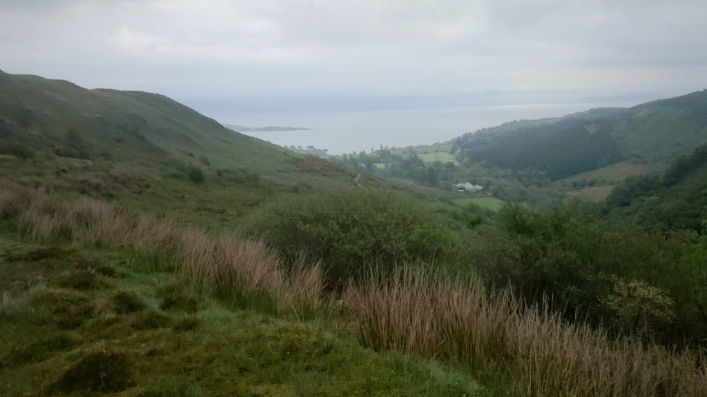
The first section started off on minor roads and wide fire roads. There were some stiff climbs early on – a taste of things to come. I’d opted for a cyclocross bike as I thought it would be good on the fireroad sections and was my least broken bike, and Elizabeth had gone for a 29er with CX tyres. The flaw in my plan was the hills and the CX bike gearing meant I was having to push hard gears up all the hills. Very quickly the route starts to feel remote as it winds through the interior of the peninsula. The going was good, with occasional sea views, before we reached a farm where the cows had churned the trail into a knee deep mire. A stiff hike a bike followed before the trails opened out and a nice descent took us down to the east coast near Carradale. A spin along the beach brought us to the village and the local shop / bakery were some cakes were scoffed. It was a good chance to check progress and look at maps. We were roughly half way and making great time.
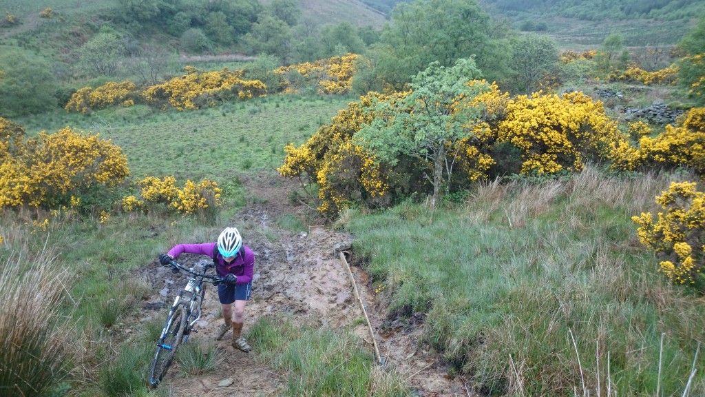
Cow Churned Bog
Campeltown to Tayiloan
The route cuts back across to the west coast from Carradale. On the map it looked there would be a big old climb. Straight from Carradale the route follows interesting singletrack up onto the hill. The gradient was steep but I was demerited not to walk and grunted and stamped my way up. The views on this sections were great and a fast open descent brought us to the road. The route then heads up to one of the big windfarms in the area via a fireroad of despair that climbed forever. Once up on the top a very bleak and open section followed before descending in the lashing rain to Tayinloan. The climb had taken a lot of effort and it was now 1pm and only three hours to the ferry. At our current average speed it would be touch and go.
Tayinloan to Claonaig
We regrouped, soaked, in the cafe at Tayinloan.. The big problem was we had no idea what the trail was like to Claonaig. Ominously it wasn’t even shown as a path on the OS map and the route climbed up high over the hills. We were 50:50 on whether we’d make it with the time left but we decided just to go for it, and fuelled up on coffee and cake we set off.
Happily the trail over the hills turned out to be the highlight of the route. After a long drag up a track the route turned to well made singletrack that carried on for 8km accross the hill tops and past some lochens. A real treat, and soon views of Arran opened up and were descending to the ferry. We had only seen 4 people all day on the route so it was nice to bump into a group of roadies waiting for the ferry. Clanoaig has no facilities at all, so their brilliant chat made shivering in the bus shelter a bit more bearable.
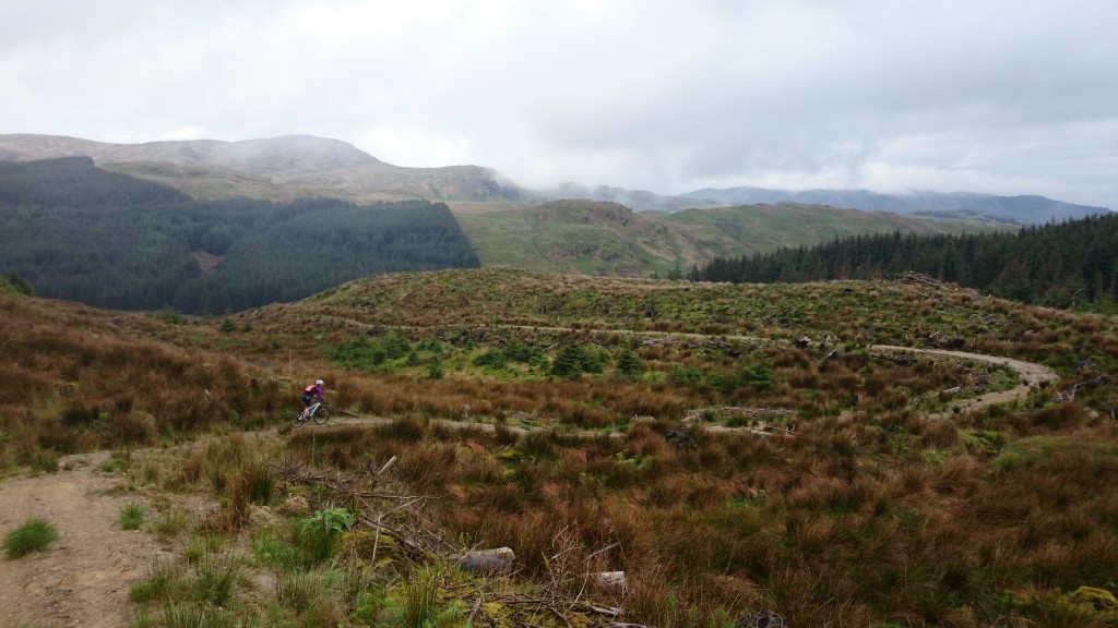
Singletrack
The Finale
It was a bit of struggle getting the legs working when we got Arran. The stiff climb out of Lochranza focused the mind and soon we were spinning along the coast to Brodick. My energy had started to fade by this point but luckily Elizabeth was still going strong and with a bit of teamwork we were soon at the ferry. There was a good feeling of achievement to finish the ride, it felt like we’d managed t cover a lot of ground and water in one day.
Thoughts on the Kintyre Way
The section from Cambeltown to Calonaig is ideally suited for biking, in fact it’s probably a better bike route than walking route. There’re enough interesting bits to make it worthwhile on a fast mountain bike but it could equally be done on a CX bike or sturdy tourer. The climbing shouldn’t be underestimated – around 1600m in this stretch alone which stacks up against some demanding highland routes. The views are great and it has a really remote feel in places. The Kintyre penisula is teeming with birdlife and other flora and fauna which makes a change from some of the more bleak highland riding. I’m very keen to go back and do the first section from Southend to Cambeltown and the last bit from Claonaig to Tarbert. The route is very well waymarked, probably the best of all the long distance routes I’ve seen. It seems little used though, which is a shame. It would be great to see a few more people using it and it would help stop the grass reclaiming some of the paths!
Using the ferry and doing a sort of “mtb three ferries” route is a good option for seeing most of the route in a day. Although, an early start or fast riding is needed to get the ferry to Arran.
Useful info
Kintyre way website (http://www.kintyreway.com/index.php)
Campbeltown Backpackers (http://www.campbeltownbackpackers.co.uk/)
Ferry times (http://www.calmac.co.uk/timetables/calmac-summer-timetables.htm)
The route is shown in full on OS Landranger Maps 62 & 68

Great write up Tom. I’d be keen to give this a go.